
THIS AVALANCHE ADVISORY EXPIRED ON January 29, 2022 @ 9:30 pmAvalanche Advisory published on January 28, 2022 @ 9:30 pm
Issued by
Brian Newman - Gulmarg Avalanche Center
Bottom Line
How to read the advisoryVarious alpine avalanche paths in the alpine region have a deeply buried weak layer and may be hanging in the balance. A single rider may trigger large, destructive avalanches. When selecting your route in the backcountry, remain conservative. Slopes which have previously avalanched are a better choice to begin your selection process. North alpine aspects may also have soft slab avalanche risk near ridgetops created by southerly winds.

2. Moderate
?
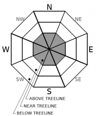
Alpine - 3000 meters and above
Heightened avalanche conditions on specific terrain features. Evaluate snow and terrain carefully; identify features of concern.
1. Low
?
Transistional - Near 3000 meters
Generally safe avalanche conditions. Watch for unstable snow on isolated terrain features.
1. Low
?
Sub-Alpine - Below 3000 meters
Generally safe avalanche conditions. Watch for unstable snow on isolated terrain features.
Heightened avalanche conditions on specific terrain features. Evaluate snow and terrain carefully; identify features of concern.
Avalanche Problem 1: Deep Slab
-
Type ?

-
Aspect/Elevation ?
-
Likelihood ?CertainVery LikelyLikelyPossible
 Unlikely
 -
Size ?HistoricVery LargeLargeSmall

Weather and CURRENT CONDITIONS
weather summary


View detailed snow forecast for Gulmarg at:
snow-forecast.com
Disclaimer
This avalanche advisory is provided through a partnership between the Jammu and Kashmir State Department of Tourism and the Gulmarg Avalanche Center. This advisory covers the Pir Pinjal range accessible from the Gulmarg Ski Area. Click here for a map of the forecast area. This advisory describes general avalanche conditions and local variations always occur. This advisory expires 24 hours after the posted time unless otherwise noted. The information in this advisory is provided as public a service. The user of this information accepts all risks and responsibility.


